


Cheyenne 5, Cheyenne County, Colorado
About
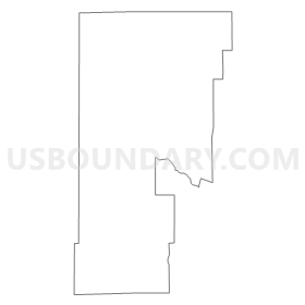
Outline
Summary
| Unique Area Identifier | 547089 |
| Name | Cheyenne 5 |
| County | Cheyenne County |
| State | Colorado |
| Area (square miles) | 364.78 |
| Land Area (square miles) | 363.51 |
| Water Area (square miles) | 1.27 |
| % of Land Area | 99.65 |
| % of Water Area | 0.35 |
| Latitude of the Internal Point | 38.84042040 |
| Longtitude of the Internal Point | -103.04027370 |
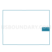
Maps


Graphs
Select a template below for downloading or customizing gragh for Cheyenne 5, Cheyenne County, Colorado


Neighbors
Neighoring Voting District (by Name) Neighboring Voting District on the Map
- Cheyenne 4, Cheyenne County, CO
- Kiowa 3, Kiowa County, CO
- Kiowa 4, Kiowa County, CO
- Kit Carson 11, Kit Carson County, CO
- Kit Carson 13, Kit Carson County, CO
- Lincoln 10, Lincoln County, CO
- Lincoln 8, Lincoln County, CO
Top 10 Neighboring County Subdivision (by Population) Neighboring County Subdivision on the Map
- Flagler CCD, Kit Carson County, CO (1,188)
- Hugo CCD, Lincoln County, CO (1,053)
- Eads CCD, Kiowa County, CO (890)
- Karval CCD, Lincoln County, CO (651)
- Kit Carson CCD, Cheyenne County, CO (493)
- Haswell CCD, Kiowa County, CO (115)
Top 10 Neighboring Unified School District (by Population) Neighboring Unified School District on the Map
- Genoa-Hugo School District C-113, CO (1,348)
- Arriba-Flagler School District C-20, CO (1,141)
- Eads School District RE-1, CO (1,103)
- Hi-Plains School District R-23, CO (570)
- Kit Carson School District R-1, CO (482)
- Karval School District RE-23, CO (326)
Top 10 Neighboring State Legislative District Lower Chamber (by Population) Neighboring State Legislative District Lower Chamber on the Map
Top 10 Neighboring State Legislative District Upper Chamber (by Population) Neighboring State Legislative District Upper Chamber on the Map
Top 10 Neighboring 111th Congressional District (by Population) Neighboring 111th Congressional District on the Map
Top 10 Neighboring Census Tract (by Population) Neighboring Census Tract on the Map
- Census Tract 9618, Lincoln County, CO (2,104)
- Census Tract 9606, Cheyenne County, CO (1,836)
- Census Tract 9601, Kiowa County, CO (1,398)
- Census Tract 9623, Kit Carson County, CO (1,188)
Top 10 Neighboring 5-Digit ZIP Code Tabulation Area (by Population) Neighboring 5-Digit ZIP Code Tabulation Area on the Map
- 80821, CO (1,093)
- 81036, CO (962)
- 80815, CO (911)
- 80825, CO (422)
- 80834, CO (318)
- 80823, CO (203)
- 81045, CO (88)
- 80862, CO (31)